
Mapping the Monadnock Region – An Historical Perspective
Mapping the Monadnock Region – An Historical Perspective
By David L.H. Allen
Article from Monadnock Perspectives, Volume 4, Number 1, Spring 1983
The Monadnock Region has been displayed on maps from the time of the first settlements in the early 18th century. The earliest maps were simple outline maps which showed the boundaries of the land grants (the towns) and little else. No roads or geographic features were shown on these maps, some of which date to the 1730s. As settlement spread and population grew, better maps were made. Accuracy and the amount of detail increased. Roads came to be shown and settlements were noted. By the mid-l9th century printing improvements made possible very detail ed maps and atlases which charted all roads and even homesites. U.S. Government surveys were completed at the close of the century, when the first “topographical” maps of New Hampshire were published. These latter maps were the first truly accurate ones, as they were based on triangulation among several of the state’s mountain peaks. With the present century came the automobile and the familiar road maps. This article however, will be limited to maps made before 1900.

While most of the historically useful maps of the Monadnock Region are printed maps design ed for wide distribution, early town plans are exceptions. These manuscript maps — simple outline maps of the town boundaries, were made when the town lines were laid out (Figure 2). The same men who blazed the boundaries on the ground drew them on the map. The purpose of the map was to separate the ownership of one town from the next and to determine the area within each. Thus, they contain almost no geographical details. No roads were shown, as at that time there were none. A typical “proprietor’s plan” might have a corner noted as “a beach tree marked . . . with stones about it’’.
Even in the first decades after settlement, very few detailed maps were available. There was no need for town road maps, as travel was a luxury, and the inter-town routes that existed were well known to the local inhabitants. To find more in formation on the early decades of settlement, we must look at the broader maps of the Province and later the State of New Hampshire. Several of the illustrations accompanying this article are taken from these much larger maps.
It should be noted that the dates cited for old maps are those of their publication, which often occurred years after the data was collected. This is important to keep in mind in the case of New Hampshire maps because the interior was being settled at a rapid pace at the same time these maps were being produced — the last decades of the 18th century. Thus a date of 1775 on a given map, while necessary to report, probably post dates the actual political changes shown on the map by several years.
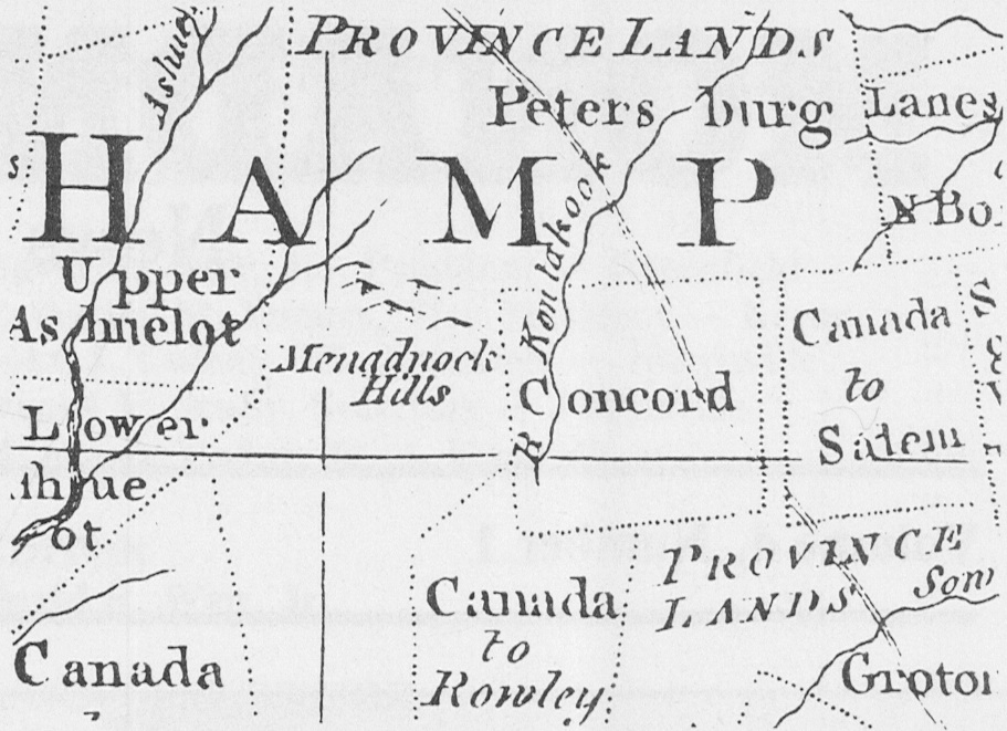
A series of European-made maps dating from about 1750 show similar details of this part of New Hampshire (Figure 3). These maps — most of them based on a single early work are the first to show town relationships and achieved wide circulation. Common to these maps are the entries “Menadnock Hills” (Mt. Monadnock) and “Kontakook River” (Contoocook). The maps also delineate the early-settled townships in this region, including Upper and Lower Ashuelot (Keene and Swanzey) and Concord (Peter-borough — first granted to residents of Concord, Massachusetts). Unsettled areas had less specific —2— names. The Rindge-Jaffrey area, for example, is shown as Canada-Rowley, so named because it was given to residents of Rowley, Massachusetts who had served in a military expedition to Quebec. The lands to the north of Peterborough, which today include Hancock and Bennington, were Province Lands, ungranted territory still belonging to the Province of New Hampshire.
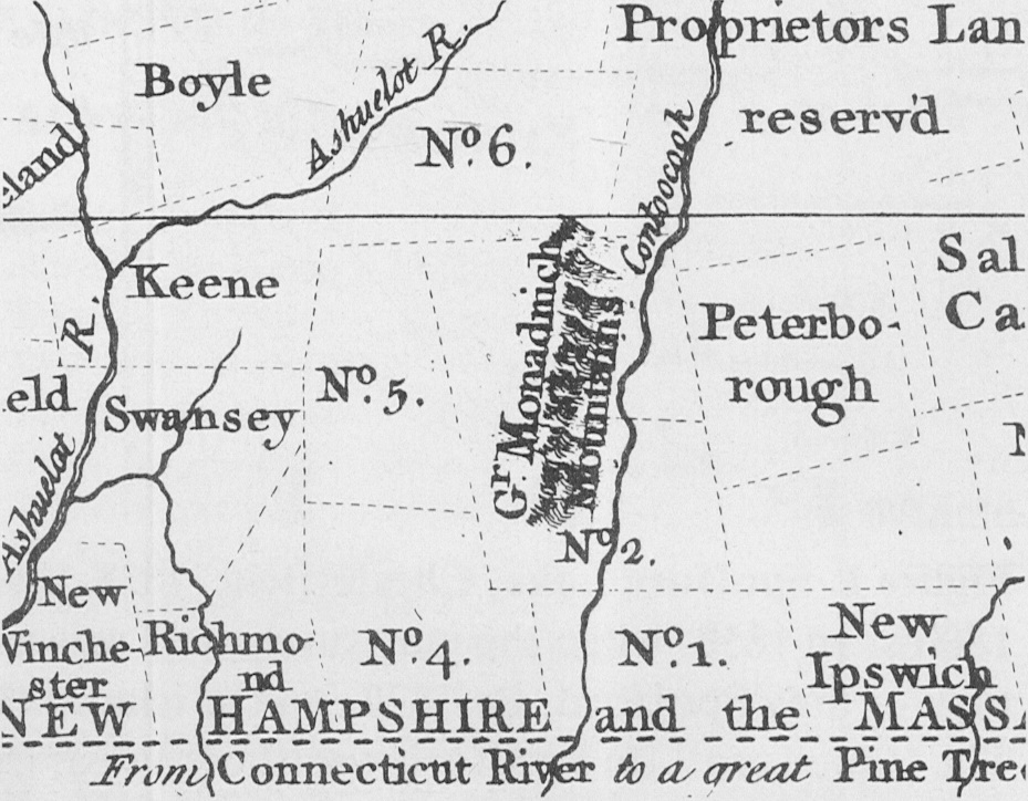
An important map of New Hampshire was made during the French and Indian or Seven Years’ War. Unlike its European contemporaries, the Blanchard and Langdon map of 1761 was based largely on actual field surveys (Figure 4). Joseph Blanchard had mapped the Connecticut River, and was responsible for some of the early proprietor’s plans of the Monadnock region. This map was the first to show New Hampshire town boundaries from the Connecticut River to the sea. In this area the map shows the interrelationships among the towns more accurately than the European maps. The Blanchard and Langdon map describes the Province in 1756, the date of its manuscript, though it wasn’t printed until 1761. The active conflict in North America was no doubt cause of the delay. In mid-century, Southwestern New Hampshire was on the New England frontier, and armed skirmishes with Indians were not uncommon.
Several area towns were unsettled when the map was drawn, although most had been granted by this time. The towns closest to Mt. Monadnock were named for that landmark, and assign ed numbers: #2 on the Blanchard and Langdon map was called Monadnock #2 and is now Jaffrey.
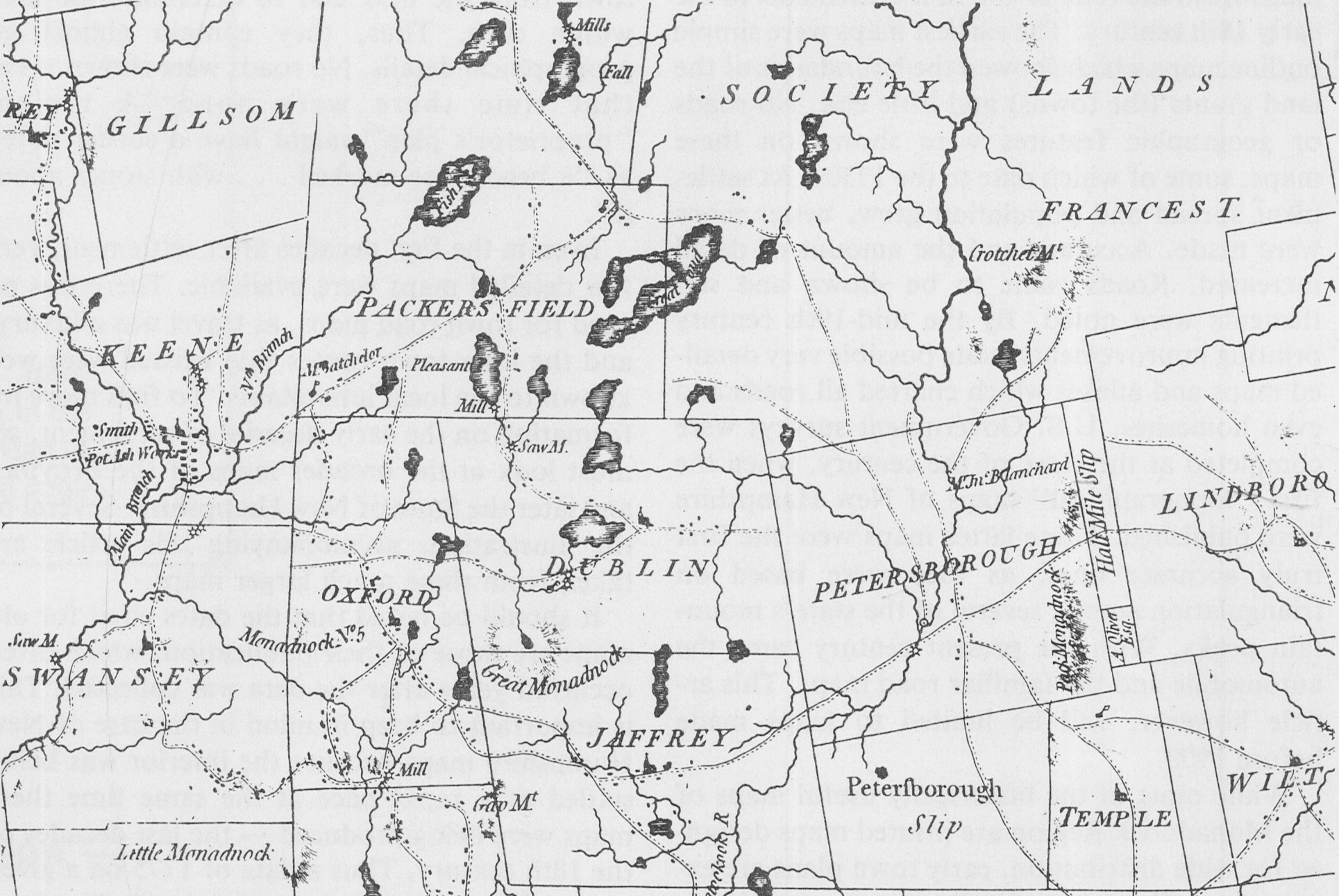
As New England entered a period of rapid growth after the hostilities ended a new map was needed. In 1772, the Province commissioned a map known today as the Holland Map. Prepared by the British Surveyor-General, Samuel Holland, this finely detailed map is based on field work done in 1773-74, and provides a most useful glimpse of the Monadnock region before the Revolutionary War (Figure 5). As with the Blanchard and Langdon map, its publication was delayed. Mapmaker Holland, a loyalist, left the colonies with his notes in 1775. The map was printed after the war, in 1784. The large size of this map has limited its utility to students of history, but a close examination reveals considerable detail. Most importantly, it shows a large network of roads — the first New Hampshire map to do so. Even a few names of property owners are recorded. It is likely that the surveyors visited this area personally, as most available town maps offered no such comprehensive information. Some villages and roads are remarkably well shown. For example, the several roads in the south part of Oxford (now Troy) correspond with existing routes in that early crossroads settlement. The map correctly shows the first settlement in Peterborough along present Old Street Road, high ground above the river. In Jaffrey, too, the main settlement is seen on its hill location — now called Jaffrey Center. No houses are shown on the Contoocook River in Jaffrey in 1784.

By 1816, many changes have occurred. Province was now state, and the economy was evolving. The Carrigain map of that year (done by Secretary of State Philip Carrigain) shows a turnpike bisecting Jaffrey (Figure 6). This was the Third New Hampshire Turnpike, a major route —3— between the upland towns of New Hampshire and Vermont and the larger seacoast settlements of Eastern Massachusetts. Among the goods carried by this highway would have been products of the new mills on New Hampshire’s many streams. Both Jaffrey and Peterborough had mills on the Contoocook when the Carrigain map was published. These mill sites would eventually grow into the principal villages of both towns. Another interesting feature on the early maps is in Dublin. The Carrigain and Holland maps both show the main route west to Keene passing south of the lake, on the lower slope of Mount Monadnock. This was the most direct route, and would continue to be for years to come.
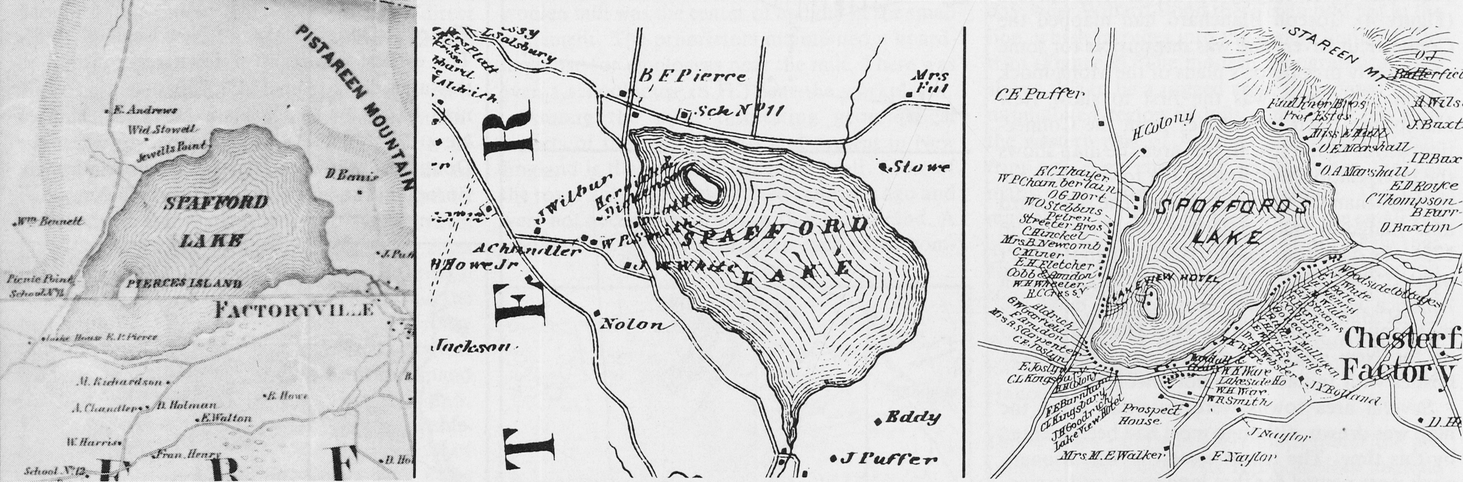
During the period when these large New Hampshire maps were being published, manuscript maps of various sorts continued to be drawn, although very few had any details of culture or geography such as those exhibited by the Holland and Carrigain maps. Hand drawn maps could not be widely circulated, so the costs of collecting data could not be recovered through sales of a finished map as presumably was the case with the state maps. The enormous expense of printing in the early 1800’s made impossible the publication of any maps with limited demand such as a town, or even a county map. Technology changed this by mid-century. Printing became simplified, and the publication of engraved works such as art prints and maps became a less expensive endeavor. (The mass-market Currier and Ives prints first appeared at this time). A result of the improvements in technology was the production of the first complete road maps for all of the towns in the Monadnock region (and elsewhere in the state). These maps were made for sale and the costs of printing and determining facts of geography, roads and settlement could be recovered by income from sales. Mid-century maps show every road, many geographic features and the names of all homeowners. The earliest of the genre in this area is Gibbs’ 1850 Map of Jaffrey. This is a wall map, measuring about two by two and a half feet. The map shows every road in the town and names each homeowner, business owner, church and school. The Jaffrey map was followed by a similar one of Dublin, and in 1858 by the large wall maps of Cheshire and Hillsboro Counties. The county maps were richly hand-colored and were mounted on canvas and affixed to rollers. As with the Jaffrey map, the county maps were comprehensive. All public roads in each town were shown, as were the names and sites of homesteads. Demand was probably quite good as both county maps are known to have had second printings. The success of the 1858 publishers is to our benefit, as these maps are fairly common today, some surviving in good condition. These maps were the most accurate yet printed, and provided a significant increase in detail over the earlier state maps. County maps were made of all of New Hampshire, and they served as the basic state maps until the United States Geological Survey maps were published beginning in the 1880s.
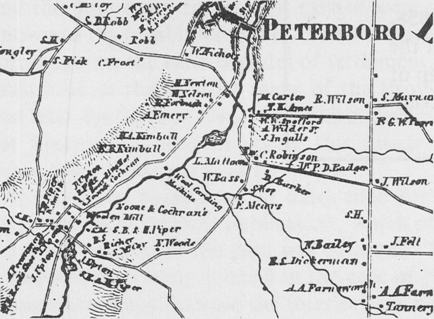
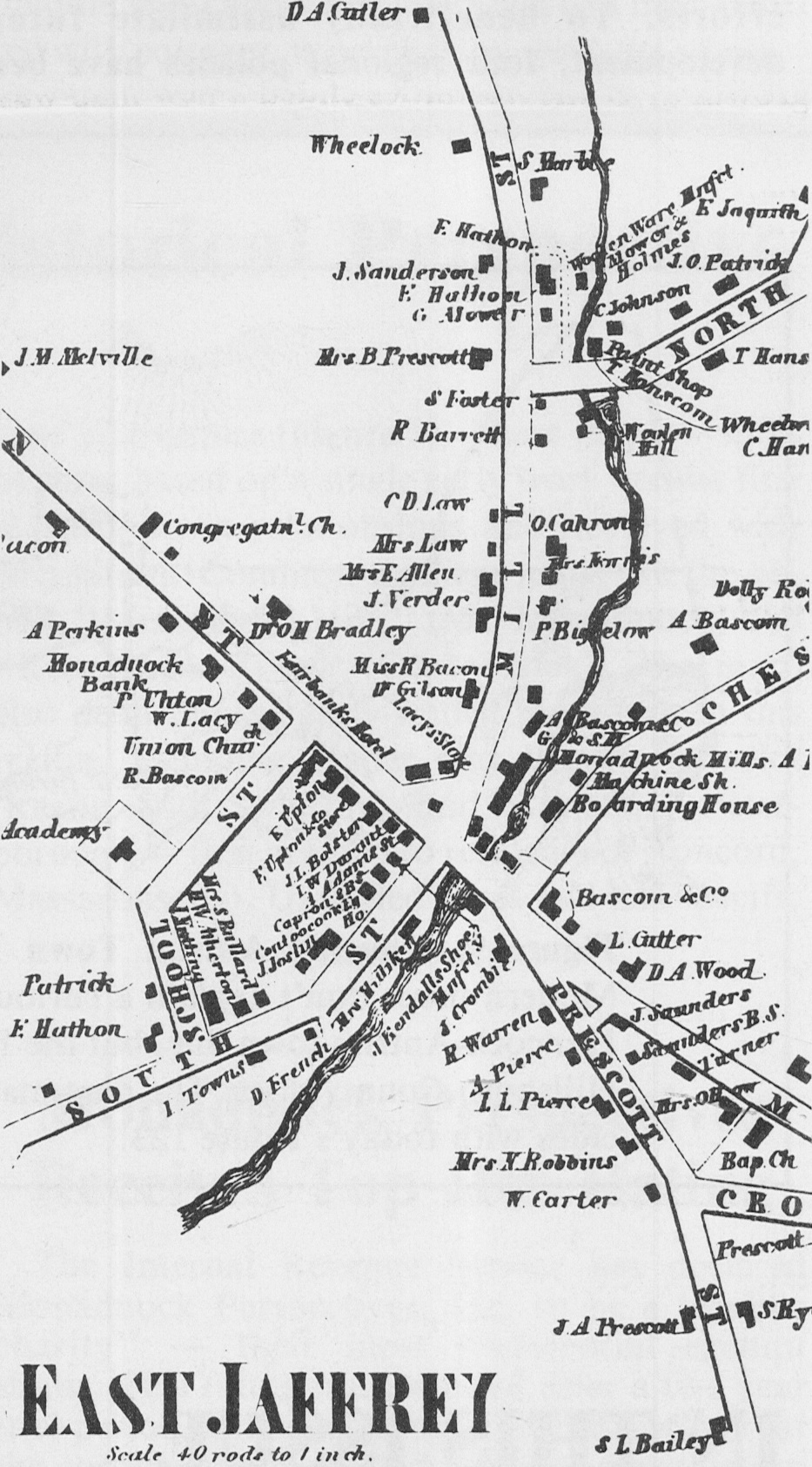
The county maps show significant changes from the time of Philip Carrigain’s state map earlier in the century. Referring to Peterborough and Jaffrey we see that the mill villages have out stripped the old hill settlements in population and economic importance (Figures 7 and 8). A glance at the 1858 map of Peterborough reveals nothing to suggest that Old Street Road was once the prime settlement in that town. Likewise, in the Town of Jaffrey, the village on the Contoocook River is the site of numerous manufactories based on the plentiful water power. That village was called East Jaffrey in 1858, but in a short time it would even assume the name of the town’s center village, consigning to the latter the diminutive Jaffrey Center.
Many of our present road and place names derive from the names of early residents. Noone, in the Town of Peterborough is such a place. On the 1858 map we see that Noone and Cochran’s woolen mill was the center of activity in the small settlement. The proprietors maintained a boardinghouse for employees near the mill. There was even a schoolhouse (S.H.) near the workplaces.
Among the most interesting geographical aspects of the political past and present in New England is the shape of the town itself. Most of the town lines were determined centuries ago and were not necessarily drawn with logic in mind. A standard of sorts was to have each town comprise about thirty-six square miles. Thus many of the towns in Cheshire and Hillsboro County are about that size. Many are roughly rectangular. But most of our town lines differ from the ideal of straight lines and right angles due either to geographical or political considerations. Indeed these strangely shaped outlines do much to make maps of New England such attractive documents. (Order prevailed when the West was subdivided — maps of the prairie states are as monotonous as the landscape). This essay will close with one example of a peculiar town line — the boundary between Antrim and Hancock. Today, near Willard Pond there is an odd jog in the line, which intrudes into the logical limits of Antrim (Figure 9).
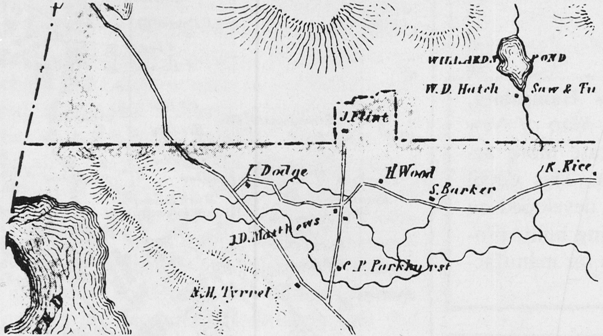
The modern topographical map shows this to be a rugged area, dominated by an uninhabited region of hills comprising much of the western part of Antrim. This corner of Antrim was even empty of settlers when the old maps were made, with one exception. The 1858 map shows a J.Flint located within the small jog in the Hancock-Antrim line. Is it not likely that Flint (or a predecessor) built his homestead on land that was part of Antrim? The isolation of this site from the rest of Antrim no doubt led to the redrawing of the town line around the old Flint homestead, thus joining it to the town of Hancock.
David Allen publishes early maps under the imprint of Old Maps. His reproductions include 19th century maps of Cheshire and Hillsboro counties. He lives in West Chesterfield, NH. This article was first published in the Spring, 1983 issue of Monadnock Perspectives (West Peterborough, NH).