|


|
|
|
|
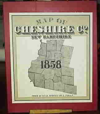
Map of Cheshire
County, New Hampshire
1858 |
| An
attractively boxed portfolio of maps, charts and engravings,
completely reproducing the original 1858 "Map of Cheshire County, NH". There are 18 full-scale
town
maps and 25 village map details. Shows 1000s of homeowner
names and their house locations. A great resource for genealogy.
Fine quality acid-free paper. |
 |
-
43 town and village maps
-
6 historical engravings (Mt.
Monadnock ..)
-
acid-free paper
-
boxed set, 36 sheets, 14" x 17"
Also Available:
1858 Wall Map
Reprint
1858 Individual Town Map Prints
|
|
Click here
to order this on our new site! |
|
|
|
|
|